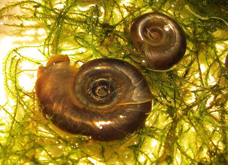
New technologies can more effectively track freshwater snails and prevent tropical disease schistosomiasis
Google Earth, satellite images and drone photos can help identify which remote communities are most at risk of contracting one of the world’s worst tropical diseases – schistosomiasis, researchers have found.
An international team led by the University of Washington and Stanford University, assisted by Royal Veterinary College (RVC) researcher Professor Joanne Webster, have used these technologies and battled the elements, risk of infection and feral dogs to precisely map communities that are at the greatest risk of this parasitic disease.
Over 220 million people have schistosomiasis, which is treatable but has been difficult to eliminate from some regions of the world. Schistosomiasis is caused by schistosomes, worms that multiply within freshwater snails and which infect people (and animals) by penetrating their skin when they swim in bodies of water inhabited by the freshwater snails. The disease causes abdominal pain, bloody urine and stools and can damage the liver, spleen, intestines, lungs and bladder. It can stunt growth and cognitive development in children as well. The disease is prevalent across sub-Saharan Africa, South America, the Caribbean, the Middle East and South East Asia.
The WHO has set ambitious goals for controlling schistosomiasis morbidity by 2020, eliminating it as a public health problem in all endemic countries by 2025, and complete interruption of transmission in selected regions by 2025. However, reports of schistosomiasis being more prevalent than previously thought, its persistence and/or re-emergence in previously cleared areas, together with potential reduced drug efficacy in populations under high drug pressure, all serve to highlight that additional control strategies must be introduced if this major disease is to ever reach elimination. The WHO therefore made the recommendation to also target the snail intermediate hosts. This was the catalyst for this team of researchers to step in.
Despite the humid weather, the danger of infected water and even feral dogs, the researchers mapped the distribution of freshwater snails over 30 sites in North West Senegal. They found that there was no consistent location for a large grouping of snails that could be targeted for removal. So, they shifted their focus to snail habitat features; the snails live in unrooted floating vegetation. The researchers cross-referenced that information with their data on snail density, village size and location. They then concluded that the total area of a water access point for humans and the area of any nearby floating vegetation were the two best indicators as to whether human infection would occur in a particular location.

Image credit: Oregon State University via Flickr
They also identified that these habitat features are all easy to measure using drone or satellite imagery. This research means public health agencies in Senegal, and beyond, can now use aerial imagery to identify likely human infection points and target those villages for schistosomiasis treatment and snail control.
Joanne Webster, Professor of Parasitic Diseases, at the RVC, said: “This is extremely exciting research as the use of new technologies deployed could allow medical (and veterinary) agencies to predict and divert resources to where they will be most likely needed. Whilst snail surveys take hundreds of person-hours per site, data collected through drone or satellite imagery would enable large-scale risk mapping of snail habitats providing the much needed complement to ongoing mass drug administration activities.”
Chelsea Wood, an assistant professor in the UW School of Aquatic and Fishery Sciences and lead author of the paper said: "This is a game-changer for developing-country public health agencies because it will make it possible for them to efficiently find the villages that need their help the most."
Co-author Giulio De Leo, a biology professor at Stanford University said : "Now we can take these aerial images season to season and have an idea of how the pathogenic landscape changes in time and space. This can give us a better idea of infection rates. This project has been a tremendous effort and an example of collaborative research that would be impossible by a single person or a single lab."
Research reference
‘Precision mapping of snail habitat provides a powerful indicator of human schistosomiasis transmission’ is published in Proceedings of the National Academy of Sciences.
Notes to Editors
For more information please contact:
- Ploy Radford (ploy.radford@plmr.co.uk) or Jasmin De Vivo (Jasmin.DeVivo@mangomarketing.com)
- Press Line: 0800 368 9520
About the RVC
- The Royal Veterinary College (RVC) is the UK's largest and longest established independent veterinary school and is a Member Institution of the University of London. It was the first in the world to hold full accreditation from AVMA, EAEVE, RCVS and AVBC.
- The RVC is ranked as the world’s number one veterinary school in the QS World University Rankings by subject, 2019.
- The RVC offers undergraduate and postgraduate programmes in veterinary medicine, veterinary nursing and biological sciences.
- In 2017, the RVC received a Gold award from the Teaching Excellence Framework (TEF) – the highest rating a university can receive.
- A research led institution with 79% of its research rated as internationally excellent or world class in the Research Excellence Framework 2014.
- The RVC provides animal owners and the veterinary profession with access to expert veterinary care and advice through its teaching hospitals and first opinion practices in London and Hertfordshire.
You may also be interested in:
-
RVC researchers at forefront of new zoonotic funding programme
The RVC has been awarded more than £5 million as part of a multimillion pound research programme to …

